

During the winter of 2009-2010 a Home Depot store was constructed at a site on state Route 111 in northern Trumbull (aka Long Hill). This site initially saw some grading and rock removal in the 1990s for a planned retail outlet known as Old Mine Plaza in allusion to the adjacent Old Mine Park. However, no construction was ever done and it sat idle until the Home Depot construction.
With its proximity to Old Mine Park, a place famous for its topaz and fluorite-rich hydrothermal veins and amphibolite-hosted scheelite and ferberite pseudomorphs thereof, the defunct plaza and the new Home Depot construction were a magnet for mineral collecting. The bedrock is mostly amphibolite, with some marble, mapped as the Silurian basal member of the Silurian-Devonian The Straits Schist, which are locally very well exposed. There was generally little overburden of Pleistocene age on the site.
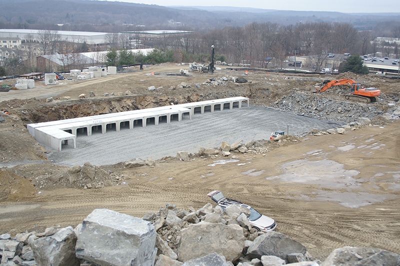
However, during the Home Depot construction a large, underground storm water storage gallery was constructed by blasting a chamber into the bedrock. This was presumably done because of the limited land available for a surface retention basin, so it was placed under the parking lot by filling the space with nested, hollow concrete structures that could support the overlying parking (see Figure 1). The walls of the gallery exposed mostly amphibolite bedrock, but the southeast corner revealed a layer of overlying glacial till.
With its proximity to Old Mine Park, a place famous for its topaz and fluorite-rich hydrothermal veins and amphibolite-hosted scheelite and ferberite pseudomorphs thereof, the defunct plaza and the new Home Depot construction were a magnet for mineral collecting. The bedrock is mostly amphibolite, with some marble, mapped as the Silurian basal member of the Silurian-Devonian The Straits Schist, which are locally very well exposed. There was generally little overburden of Pleistocene age on the site.
However, during the Home Depot construction a large, underground storm water storage gallery was constructed by blasting a chamber into the bedrock. This was presumably done because of the limited land available for a surface retention basin, so it was placed under the parking lot by filling the space with nested, hollow concrete structures that could support the overlying parking (see Figure 1). The walls of the gallery exposed mostly amphibolite bedrock, but the southeast corner revealed a layer of overlying glacial till.

Fig 1. Underground storm water retention basin under construction in January 2010. The walls exposed mostly amphibolite bedrock, but glacial till was exposed in the corner at far left (Harold Moritz photo).
I found this small till outcrop (see Figure 2) interesting because it provided a relatively rare, fresh cross-section of what appears to be the lower till. Although lower till may be volumetrically more abundant than the upper till because it cores drumlins and other areas of thick till (see Melvin and others, 1992 and Stone and others, 2005), the upper till almost completely blankets the lower till from view. If there was any upper till at this site it was stripped away by site grading. Because glacial till in general does not have much economic value there are few excavation pits were it was mined for anything other than “clean fill” on a small temporary scale.
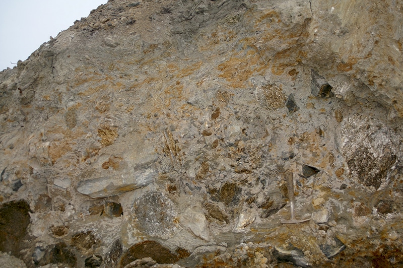
Fig. 2: Exposure of what appears to be lower till in the wall of the retention basin. Note the fine-grained, deformed matrix and tightly packed cobbles and boulders. Some of the boulders may look competent, but some could be readily crumbled by scraping with the hammer shown for scale (Harold Moritz photo).
These pits tend to expose only the surficial upper till, which is generally sandier and loose compared to the lower till and will not hold up stable walls. It apparently formed from ablation on top of melting ice rather than under it. Lower till tends to be clay-rich and so compact that it can be difficult to excavate or drill through. At a large construction site in Cromwell, along state Route 372, between I-91 and state Route 3, an excavator was used to cut into a lower till exposure. It carved a wall that was actually past vertical, with prominent bucket teeth marks. At a site along I-95 in Branford I worked at a site underlain by arkosic conglomerate where an excavator apparently refused on this rock, as did screw augers. However, subsequent drilling with a tri-cone rotary bit and water circulation passed through 10s of feet of this “bedrock” before refusing on the real bedrock. What I thought was shallow bedrock was actually dense lower till that had the same red-brown color (common in till overlying the Mesozoic sedimentary rocks) as the underlying conglomerate. Lower till at the ConnDOT facility on state Route 3 in Rocky Hill, next to Dinosaur State Park, is similarly so dense that it could only be drilled with difficulty.
Lower till lies directly on bedrock and given its compact nature was almost certainly formed under continental scale ice sheets and may have been overridden by multiple ice advances. Thus it could date back to the beginning of the Pleistocene 2.59 Ma and display evidence of deformation in the finer-grained matrix and decomposition of larger clasts. Such is the case at the Trumbull exposure.
The matrix at Trumbull is pale gray, very compact, unconsolidated silt and clay. But boulders and cobbles make up around half of the exposure. They are very tightly packed into the matrix and may be framework supported as they are almost touching in many areas and nearly fit together like a mortared stone wall. The matrix shows evidence of deformation from compaction, but also shows orange-rusty staining along fractures closer to the surface. The cobbles and boulders consist mostly of light colored to rusty schistose rocks, with only a few white marble and dark amphibolite rocks present despite their proximity. Interestingly, many of the schistose boulders were nearly completely decomposed, their feldspars altered to clays, and could be crumbled by simply scraping them with the small rock hammer shown. They were obviously very competent when emplaced but enough time has passed to allow in-situ weathering similar to the formation of saprolitic soil from bedrock, but in this case only within specific clasts. I’ve encountered similarly decomposed boulders in drill samples from lower till in Bantam, but never in upper till. Could this process have happened during only the latest glaciation of the past 100,000 years, or is it evidence that this till is from a much older Pleistocene glaciation?
References
Melvin, R. L.; Stone, B. D.; Stone, J. R.; & Trask, N. J. (1992), Hydrogeology of thick till deposits in Connecticut. U. S. Geological Survey open-File Report 92-43.
Stone, J. R.; Schafer, J.; London, E. H.; DiGiacomo-Cohen, M. L.; Lewis, R. S.; & Thompson, W. (2005), Quaternary Geologic Map of Connecticut and Long Island Sound Basin. USGS Scientific Investigations Map 2784.